WQ-29
A Shortcut to Wellhead Protection Delineation for Some Systems
Barbara C. Cooper, Water Quality Education Specialist
Jane R. Frankenberger, Extension Agricultural Engineer
Fred Whitford, Coordinator, Purdue Pesticide Programs
| Inside |
Who Is Allowed to Use the Shortcut
Method? |
How Do You Apply for Permission
to Use the Fixed Radius
Method? |
How Do You Get Your Delineation
Approved? |
| What's Next? |
| Useful Publications |
| Indiana Information Contacts |
| Sources of Topographic Maps |
Clean, safe drinking water is vital to your community’s health, economy,
and future well-being. If the ground water your community uses becomes
contaminated, it may be lost forever as a water supply, or it may require
very expensive treatment to remain usable. The best way to make sure your
water supply remains safe now and for the future is to protect the area
around your wells (the wellhead protection area) from potential hazards.
|
Wellhead Protection Planning Overview |
| Local planning team |
| Delineation of the wellhead protection area |
| Identification of potential sources of
contamination |
| Management of the wellhead protection area |
| Contingency plan |
| Public participation, education, and
outreach |
This publication describes the fixed radius method to delineate a wellhead
protection area, which may be an option for water supply systems that
pump, on average, less than 100,000 gallons per day.
What Is Wellhead Protection?
Wellhead protection is a way to protect a water supply by managing an area
around the community’s wells to prevent contamination. A team of concerned
community members guides the wellhead protection planning process. The
process involves defining and mapping the wellhead protection area,
inventorying potential sources of contamination, developing a plan to
manage the area, contingency planning for possible contamination, and
educating the public.
How Do You Identify Your Wellhead Protection Area?
The area that is most likely to affect drinking water quality and that
therefore requires added protection is known as the "wellhead protection
area." Delineation is the process of identifying the size and shape of the
wellhead protection area. Delineation is important because it serves to
focus the attention of your well-head protection planning team on
activities within the area that are potential contributors to ground water
pollution.
Potentialis the important word here, because Indiana’s Wellhead
Protection Rule emphasizes prevention rather than remediation of ground
water problems. Once your team identifies potentially harmful activities,
it can begin developing voluntary best management programs and outreach
efforts to educate those living and working within the wellhead protection
area on how to safeguard the water supply.
Indiana’s Wellhead Protection Rule (327 IAC 8-4.1) allows some
smaller communities to choose between two separate methods for
completing a delineation, depending on how much water they pump
each day and how accurate they wish their delineation to be. The more
scientific and accurate method requires hiring a consultant, a qualified
ground water scientist, to determine the area from which the community
will draw water over a five-year time period. (See "Useful Publications"
for a publication on this topic.)
Some smaller communities are able to apply to IDEM to use a "fixed radius
method." Using the fixed radius method provides a shortcut to delineation
when compared to the standard modeled delineation process. The community
public water supply systems that are eligible to use the fixed radius
method may use a circle with a 3000-foot radius around their community
drinking water supply well as a wellhead protection area.
Who Is Allowed to Use the Shortcut Method?
 If your water supply system pumps less than 100,000 gallons per day, on
average, your wellhead protection planning team may apply to IDEM for
approval to use the fixed radius method for delineating your well-head
protection area. While this method will save you time and money in the
short term, it is not as accurate as the methods using a computer model.
It may define a larger area to inventory and manage or may fail to include
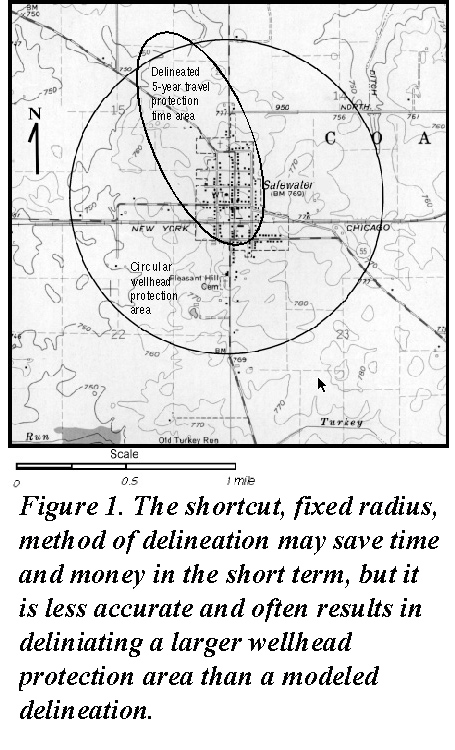
some parts of the recharge area. Figure 1 is a topographic map comparing a
3000-foot fixed radius delineation with a modeled delineation of a
wellhead protection area.
If your water supply system pumps less than 100,000 gallons per day, on
average, your wellhead protection planning team may apply to IDEM for
approval to use the fixed radius method for delineating your well-head
protection area. While this method will save you time and money in the
short term, it is not as accurate as the methods using a computer model.
It may define a larger area to inventory and manage or may fail to include
some parts of the recharge area. Figure 1 is a topographic map comparing a
3000-foot fixed radius delineation with a modeled delineation of a
wellhead protection area.
How Do You Apply for Permission to Use the Fixed Radius Method?
The first step is to verify whether your water supply system pumps less
than 100,000 gallons per day. You may use either pumping records or well
capacity data from the well log the driller filed when your well was
drilled.
- If your water supply system has long-term pumping records, you can
submit copies of the (monthly average) pumping records for the last five
years to the Indiana Department of Environmental Management (IDEM). If
your system disinfects the drinking water, this data may be found in your
monthly reports of operations (MRO’s). If your team does not have access
to five years of metered data, make sure a meter is installed, and start
collecting data as soon as possible.
- If you have well logs and well capacity data for all the wells in
your system that indicates that the combined well capacities of all the
wells is not sufficient to produce 100,000 gallons per day, you can submit
this data to IDEM as proof that your system uses less than 100,000 gallons
per day.
If you have the pumping data or the well capacity data you can apply to
IDEM for approval to use the fixed radius method of delineation. Figure 2
is a sample of a cover letter that you should send to IDEM with a request.
Substitute information specific to your particular water supply system
where it is appropriate.
Figure 2. A sample of a letter to IDEM
requesting permission to use the fixed radius method of
delineation
IDEM Office of Water Management
Drinking Water Branch/Ground Water Section
Fixed Radius Delineation Approval
P.O. Box 6015
Indianapolis, IN 46206-6015
Re: Safewater Water Works #0000000
October 6, 1999
To Whom It May Concern:
We are requesting Fixed Radius Delineation Approval for our
Wellhead Protection Plan here in Safewater, Indiana (Tippecanoe
County). You will find listed below the daily pumping averages for
five years spanning January 1994 through December 1998.
January-December 1994: 52,177 gpd
January-December 1995: 63,029 gpd
January-December 1996: 53,432 gpd
January-December 1997: 47,495 gpd
January-December 1998: 49,779 gpd
The January 1994 through December 1998 gpd average is 53,182.
The records that we are enclosing are recorded in thousands
of gallons. If you have any questions or require any more information,
please call the clerk treasurer, Mary Smith at 765-555-1111. She can
assist you in obtaining additional information.
Sincerely,
John Brown, Superintendent
Safewater Water Works
|
If you do not have the well capacity information or the five years of
pumping data, but you think that your water supply system pumps less than
100,000 gallons per day, you can contact IDEM directly (at 1-317-308-3321
or 1-800- 451-6027 ext. 308-3321) and discuss the options for getting
permission to use the fixed radius method.
How Do You Get Your Delineation Approved?
After you receive approval to use the fixed radius method from IDEM, you
need to send an application for delineation approval to IDEM. The
application should include a copy of the letter granting approval to use
the method, your well logs, and a map of the area. The following steps
will help guide your local wellhead protection plan-ning team through the
process of sending in the information to get your delineation approved.
Step 1: If available, obtain well logs of your public water supply
wells.
You can obtain well logs from the Indiana Department of Natural Resources
by calling 317-232-1106 or, toll free, 1-877-WATER 55 (1-877- 928-3755),
or by sending a letter requesting a copy to the Indiana Department of
Natural Resources, Division of Water, 402 West Wash-ington Street, Room
W264, Indianapolis, IN 46204. Each written request should include the
owner’s name, facility name, the street address, and the section,
township, and range location. (All available records are filed by section,
township, and range, so be sure this information is included.) Water well
records are also available on the Web at
http://www.state.in.us/dnr/water.
Not all wells were recorded by the well driller when they were installed.
Only the well logs that were recorded are available. If the log for your
community’s well is not available, your team should turn in a statement to
that effect with your other documentation.
Step 2: Obtain topographic maps of your area.
A listing for several sources of topographic maps is included at the end
of this publication. When ordering topographic maps, your team should be
prepared to describe your location. Providing section, township, and range
information is usually the easiest way to be sure you will receive the
correct map(s). If your area falls at the edge or corner of a map sheet,
you may need more than one sheet to show your area completely. It is a
good idea to order several copies of the maps you need-at least one as a
working map to use when you work on the contaminant source inventory
(another part of the wellhead protection planning process), one to keep
locally with a copy of your wellhead protection plan, and one for the
submission package to IDEM.
Step 3: Draw a 3000-foot radius circle around the well.
Once your team has the topographic map, you can draw a circle with a
radius of 3000 feet (1.5 inches on the map that is scaled at 1:24,000)
with the well at the center of the circle. The area inside this circle is
your wellhead protection area. Figure 1 includes an example of a circular
wellhead protection area.
Step 4: Indicate location of water withdrawal facilities.
If there are other significant water withdrawal facilities in the area,
your team should indicate their locations on the topographic map. Examples
of significant water withdrawal facilities may include industries,
agricultural processing operations, large-scale irrigation facilities, or
another public water supply system. The Indiana Department of Natural
Resources (toll-free at 1-877-WATER-55) can provide information about
water wells, including any information on significant water users.
Step 5: Submit application for delineation approval to IDEM.
The application is available on the Web at IDEM’s Web site. (See "Indiana
Information Contacts" listed at the end of this publication.) Although the
application covers the entire process, IDEM has suggested that you send
the delineation section first. Complete the first page and the top of page
4 on the application form for this part of the submission. Three things
need to be included in the initial submission to IDEM.
- A copy of the letter from IDEM granting approval for use of the fixed
radius method.
- The well log information on your public water supply system’s
pumping wells (Step 1).
- The topographic map showing:
- the wellhead protection area boundary (Step 2).
- the location of the public water supply system’s pumping wells
(Step 3).
- the locations of all other significant water withdrawal facilities in
the area (Step 4).
Send these three things along with a copy of the wellhead protection plan
application to:
Wellhead Protection Program
IDEM, Drinking Water Branch
P.O. Box 6015
Indianapolis, IN 46206-6015
IDEM will respond to your application. However, if the response takes
longer than you would prefer, your team should continue working on the
remaining parts of your wellhead protection plan. By continuing to work on
the plan, initial enthusiasm remains high, and your team makes progress
toward the goal of wellhead protection planning.
What’s Next?
Wellhead protection is a multi-step process. Once the delineation is
approved, your team can focus on the task of inventorying the wellhead
protection area for potential sources of contamination. Other tasks
include determining how to manage the wellhead protection area to reduce
the risk of contamination, contingency planning in case of future
contami-nation, and educating the public about ground water and wellhead
protection. Publications on each of these topics are available now, or
will soon be available from your local Purdue Extension county office.
(See "Useful Publications.")
Useful Publications
The following Purdue Extension publications provide information about
other aspects of the wellhead protection process.
- WQ-2, "What Is Groundwater?"
- WQ-24, "Wellhead Protection in Indiana"
- WQ-28, "Forming the Wellhead Protection Planning Team"
- WQ-30, "Choosing a Consultant to Delineate the Wellhead
Protection Area:"
- WQ-31, "Inventorying Potential Sources of Drinking Water
Contamination"
- "Protecting Your Drinking Water: What Every Citizen Should Know
About Wellhead Protection" and "Wellhead Protection: What Every
Farmer Should Know About Wellhead Protection." These short
brochures may be useful in your outreach efforts.
All these publications are free. Contact your local county Purdue
Extension office, or call 1-888-EXT-INFO to obtain these or other
publications.
The USEPA has an informative publication, "Wellhead Protection, A Guide
for Small Communities," EPA/625/R-93/002, available free by calling
1-800-490-9198.
Sources for Topographic Maps
- Purdue University, West Lafayette Campus. If you know the name of your
map, you can send a check for $4 per map, plus $2 for shipping to LARS,
Purdue University, 1202 Potter Engineer-ing Center Room 376, West
Lafayette IN 47907-1202 (765-496- 3209), or email esei@ecn.purdue.edu. Please include
your phone number in case more information is needed.
- The Indiana Department of Natural Resources, DNR Map Sales Section,
402 West Washington Street, W-160, Indianapolis, IN 46204-2742, or call
317-232-4180.
- The Indiana Geological Survey Publication Sales Office at Indi-ana
Geological Survey, 611 North Walnut Grove, Bloomington, IN 47405-2208, or
by phone at 812- 855-7636. They can determine the proper map to supply if
you provide the name of a town, river, or other named landmark nearby.
Maps are $4 each, plus tax, with a $3 shipping and handling charge.
Indiana Information Contacts
- The Purdue Extension office in your county can provide you with
information and resources on water quality protection. Look in the phone
book under "County Government," or call 1- 888-EXT-INFO.
- "Safe Water for the Future" is a Purdue Extension program that
provides resources on drinking water protection for individuals
and communities. Call 765-496-6331, or visit their Web site at
http://www.ecn.purdue.edu/safewater.
- Indiana Department of Environmental Management, Ground Water
Section, can provide information on Indiana’s Wellhead Protection Program.
Call the Groundwater Section at 317-308- 3321 or 1-800-451-6027, ext.
308-3321. Information is also avail-able on the Web at
http://www.in.gov/idem/programs/water/swp/whpp/ under "Wellhead Protection."
- Indiana Water and Wastewater Association provides training and
on-site assistance to water supply operators. They can be reached at
1-888-937-4992 or through the Web at http://www.iwwa.com.
- The Indiana "Rural" Water Association also provides education and
assistance to water supply operators. You can reach them at 812-988-6631
or Fax 812-988-6961.
NEW 3/00
It is the policy of the Purdue University Cooperative Extension Service,
David C. Petritz, Director, that all persons shall have equal opportunity
and access to its programs and facilities without regard to race, color,
sex, religion, national origin, age, or disability. Purdue University is
an Affirmative Action employer.
This material may be available in alternative formats.
1-888-EXT-INFO
http://www.extension.purdue.edu/extmedia/menu.htm