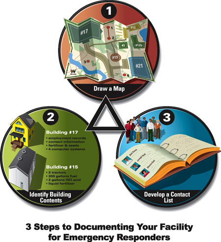
It takes only three steps to complete an emergency document that will help you deal with any type of emergency:
- Draw a map of the farm.
- List the contents of each building.
- Develop a list of contact names and numbers.
The Farm Map: What You Will See
Mapping the farm sounds complicated, but it can be a simple sketch of the farm layout that identifies the buildings and key points in the surrounding environment. The goal of mapping is to
- acquaint all employees, family members, and emergency responders with the layout of the farm.
- show hazards that might be encountered.
- help responders decide the best way to tackle a problem.
- assess vulnerable areas outside the farmstead that could be negatively affected if an emergency occurs.
- document assets for insurance and reporting purposes.
- identify crops and fields that may be targeted by agroterrorists.
Drawing a farm map may take you an hour or so, but it is extremely important. Emergency responders may have only a few seconds to determine what they are up against when dealing with a fire, explosion, accident, crime, or biohazard on your farm. Don't make the map too complicated, but do include sensitive areas like creeks, wells, and wetlands.
A concise map can be the most important source of information for first responders. For example, during a recent fire where there was no farm map, the farmer told responders as much as he remembered about what was stored in the building. About 10 minutes after the conversation, an intense explosion occurred inside the barn. The farmer was heard to say, "I forgot there was a 55-gallon drum of used oil right behind that door."
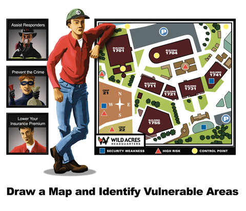
As you develop and analyze your site map, you will better understand what areas of your farm are vulnerable to intruders. It is especially helpful to review your plan with emergency personnel who have experience with these issues. Look at your site map and ask yourself, What would someone want to steal, damage, or contaminate? This will help you decide where to place additional locks, sensors, security lighting, gates, etc.
Developing Your Map
Sketch your farmstead map on plain paper at first; you can draw it to scale on graph paper once you've thought of everything you want to include.


- Write the farm name at the top of the page.
- Show the location of every building: houses, barns, equipment sheds, chemical storage facilities, etc. Write down the name of each building as it is commonly referenced by employees or family.
- Number the buildings.
- Distinguish clearly between small and large buildings; this helps responders figure out which building they're addressing.
- Site landmarks that are easily recognized: structures such as grain bins, barns, silos, and farmhouses that will help emergency responders orient themselves to your farm.
- Identify environmentally sensitive areas like creeks, wells, and wetlands (on neighboring properties as well as your own).
- Draw a directional legend for north, south, east, and west.
- Include road numbers and names on your map (top right).
- Indicate the proximity of your property to nearby communities. List the distances to schools, hospitals, nursing homes, subdivisions, etc.
- Show access lanes to your farmstead, and indicate areas that become impassible during wet weather (middle right).
- List load (weight) limits for farm bridges.
- Mark the distance to the nearest fire hydrant or water source.

- Your map should indicate wells, swimming pools, open ditches, ponds (above), rivers, creeks, and lakes that could be used as water sources; also note those that are at risk for contamination from a chemical spill or from runoff of water used to put out a fire.
- Show prevailing wind directions.
- Show locations of dry hydrants (left).
- Identify experimental or developmental plots that could become a target of anti-biotechnology groups.
- Label the locations of irrigation systems that have been modified with fittings that allow fire department use (below, right, top).
- Indicate the types and locations of all fences.
- Show gate openings and state all gate widths (below, right, bottom).
- Indicate where septic tanks, outdoor tile drains, all wells (active and abandoned), and cisterns are located.
- Show the directional slope of the land to indicate drainage patterns.
- Show pesticide and fertilizer mixing and loading areas.
- Indicate storage areas for hazardous materials such as liquid propane, fuel, and anhydrous ammonia tanks. Label each tank, stating its contents and capacity.
- Clearly mark livestock buildings that contain waste pits because of the falling hazard they present to firefighters or rescuers.
- Mark underground sewer, electrical, water, and gas lines.
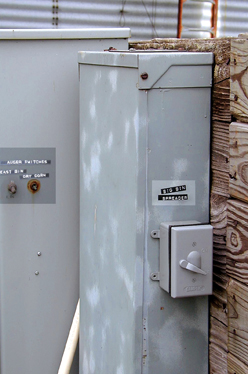
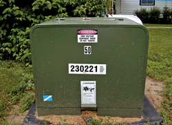
- Indicate emergency disconnect sites and switches for gas, water, and electricity (right) as well as aboveground electrical service drops. State the height of overhead lines. List each utility by name and provide an emergency phone number for each.
- Clearly indicate low power lines.
- Show where switches for electric fences are located.
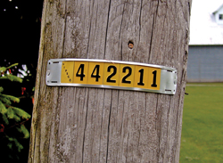
- Note the number displayed on the electric pole or box (far bottom, left).


- Indicate your designated "congregation point" where your family and employees know to meet in the event of an emergency.
 This is crucial to confirming that everyone is accounted for as the emergency unfolds.
 - Include emergency contact numbers for yourself as well as a neighbor or employee who might assist emergency responders.
- Include a long-distance contact number, if possible. In major disasters, local lines may be busy or out of service, whereas cell phones might be able to reach long distance numbers.
Buildings and Contents:
Where Things Are Stored
In some counties, 911 responders ask farmers to number each building and display the number prominently on each and every door. Cross reference the building numbers (on your farm map) with the common names of the respective buildings. Mark or describe the following with respect to each building and its contents:
- A rough floor plan
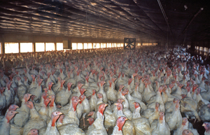
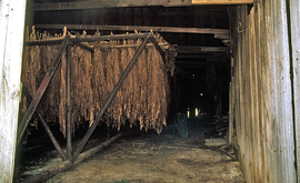
- Occupancy: Are people, animals, poultry (left) equipment, supplies, grain, hay, tobacco (below, left, top), etc., normally inside?
- Valuable equipment inside that would make it particularly important to save the building
- Building dimensions (approximate)
- Building construction date
- Type of building construction: slab? crawl space? wood trusses?
- Type of roof, windows, and floors
- Chemical storage areas: types and sizes of containers. Keep inventories current.
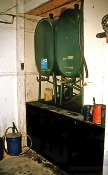
- Chemical mixing and loading areas (below, left, bottom)
- Indoor drains and where they lead
- Types of equipment: motorized? gas? diesel?
- Vehicles stored inside
- Manure pits in buildings
- Propane tanks
- Compressed gas
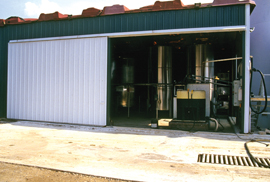
- Drums and contents (right)
Contact Numbers: Whom to Call
Provide a prioritized list of contact names and numbers in case you are away from the farm or incapacitated during an emergency. The first contact should be someone who is familiar with all operations and is authorized to make critical decisions in the event of an emergency.